CATDS Ocean salinity reprocessings RE07/CEC V7
Level 3 Sea Surface salinity reprocessed by CATDS operational centre (CPDC) and expertise centre (CEC) are now available.
Major changes in SMOS CATDS algorithms have taken place last year. All the SMOS Sea Surface Salinity (SSS) products have been regenerated and are now available.
Main outcome for the SMOS CATDS reprocessed SSS is an improved temporal stability and an improved radio frequency interference filtering. Daily, 10day and monthly SSS maps are available both in near real time and with a 5day delay (to allow a centered vicarious calibration) at CATDS CPDC operational centre (L3Q products). 9day and 18day SSS maps derived in delayed mode with enhanced filtering produced by CATDS Ocean Salinity Expertise Centre (CEC-OS) are available for the period January 2010-November 2021 (CEC V7 products). All the above CATDS SSS products include systematic corrections for land-sea contamination and for seasonal-latitudinal artificial variations.
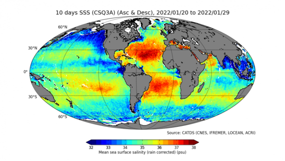
Figure 1 : SMOS SSS 10day map derived in near real time (20 to 29 January 2022)
The algorithms implemented in SMOS CATDS CPDC reprocessing RE07 (January 2010-May 2021) and operational processing since June 2021 have been updated as follows :
- Use of the new Level 1b data from ESA v7 reprocessing (gibbs 2 image reconstruction algorithm),
- CATDS level 2 processing using level 2 ESA v7 processing improvements (new dielectric constant model (Boutin et al. 2021) and specific RFI filtering),
- CATDS level 3 pre-processing : correction for bias and rain instantaneous effect. CATDS land/sea and latitudinal seasonal bias correction method have been aligned with CATDS CEC V5 methodology and applied to the new products. Rain instantaneous effect has been estimated in 1mm hr-1 IMERG rain rate classes (see Fig5 of Supply et al., 2020) and corrected before biases estimates.
- Level 3 operational processing (L3Q products) : Operational SSS estimates with and without rain correction are provided. In rainy areas, rain corrected SSS is close to a bulk salinity.
- Level 3 delayed mode processing (CEC V7 products) : science experimental products. Bias correction method similar to V5 but with biases estimated over different period/regions (see documentation).
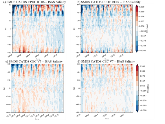
The comparison of reprocessed SSS to Argo optimal interpolation (ISAS) maps shows a much better stability of SMOS SSS with respect to the previous versions (Figure 2 ; top CPDC products; bottom CEC products). Detailed comparisons with Argo are available at Pi-Mep (https://www.salinity-pimep.org), we report below some striking results based on global scale comparisons with Argo SSS, the robust standard deviation of the difference and determination coefficient (r2) between SMOS SSS and Argo:
r2 | Robust std | r2 | Robust std | ||
CPDC RE06 (v317) – monthly SSS | 0.881 | 0.26 | CPDC RE07 (v335) – monthly SSS | 0.898 | 0.21 |
CEC V5 - 18day | 0.968 | 0.20 | CEC V7 - 18day | 0.971 | 0.19 |
N.B. : CPDC SSS have an effective resolution of ~50km ; CEC SSS have an effective resolution of ~70km (a median/mean filtering over nearest neighbours is applied).
Figure 2: Latitudinal-time plots of SMOS minus ISAS salinity. a) SMOS CPDC RE06; b) SMOS CPDC RE07 (including correction for instantaneous rainfall. c) SMOS CEC V5 ; d) SMOS CEC V7.
References :
Boutin, J., J.L. Vergely, E. Dinnat, P. Waldteufel, F. D’Amico, N. Reul, A. Supply, C. Thouvenin-Masson (2020), Correcting Sea Surface Temperature Spurious Effects in Salinity Retrieved From Spaceborne L-Band Radiometer Measurements, IEEE Transactions on Geoscience and Remote Sensing, 1-14, doi:10.1109/tgrs.2020.3030488.
Supply, A., J. Boutin, G. Reverdin, J.-L. Vergely, and H. Bellenger, 2020: Variability of satellite sea surface salinity under rainfall. In: Satellite Precipitation Measurement, V. Levizzani, C. Kidd., D. B. Kirschbaum, C. D. Kummerow, K. Nakamura, F. J. Turk, Eds., Springer Nature, Cham, Advances in Global Change Research, 69, 1155-1176, https://doi.org/10.1007/978-3-030-35798-6_34.


