Updated and new ocean salinity (SSS) operational products
One existing ocean salinity (SSS) operational product has been updated, and two new ocean salinity operational products are available at CATDS:
Updated L2Q product
The format of the L2Q product has been updated in order to be more compliant with the CF convention.
The files with the new format are tagged with the processor version 331, while the files with the old format are tagged 330. Both series (old and new format) since 2010 are available at the moment, but the files with the old format will be removed around mid february 2023.
For those who struggle to adapt their procedures to the new format, here is a batch of nco commands to convert a file in the new format to a file similar to the old one:
ncrename -h -v Sea_Surface_Salinity,Sea_Surface_Salinity_Model1_Value file_name.nc
ncrename -h -v Sea_Surface_Salinity_Error,Sea_Surface_Salinity_Model1_Error file_name.nc
ncrename -h -v Sea_Surface_Salinity_Bias_Correction,Sea_Surface_Salinity_Model1_Bias file_name.nc
ncrename -h -v Sea_Surface_Salinity_Classes,Sea_Surface_Salinity_Model1_Classes file_name.nc
ncrename -h -v Sea_Surface_Salinity_Rain_Corrected,Sea_Surface_Salinity_Model2_Value file_name.nc
ncrename -h -v Sea_Surface_Salinity_Rain_Corrected_Error,Sea_Surface_Salinity_Model2_Error file_name.nc
ncrename -h -v Sea_Surface_Salinity_Rain_Corrected_Bias_Correction,Sea_Surface_Salinity_Model2_Bias file_name.nc
ncrename -h -v Sea_Surface_Salinity_Rain_Corrected_Classes,Sea_Surface_Salinity_Model2_Classes file_name.nc
ncrename -h -v Acard,Sea_Surface_Salinity_Model3_Value file_name.nc
ncrename -h -v Acard_Error,Sea_Surface_Salinity_Model3_Error file_name.nc
ncrename -h -v Acard_Bias,Sea_Surface_Salinity_Model3_Bias file_name.nc
New L3G product
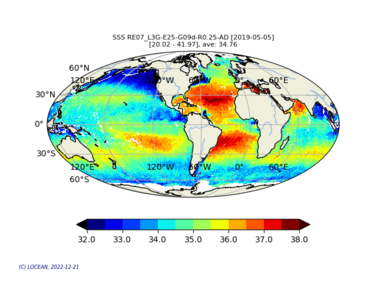
A new L3G product is now available.
The L3OS 3G product contains daily salinity fields from a 9 days temporal gaussian average, corrected from land-sea contamination and latitudinal bias, based on L2Q products, mixing ascending and descending orbits
New L4 SMOS-OI product
A new L4 SMOS-OI product is now available.
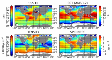
The L4OS SMOS-OI product contains global Level 4 analyses of the of the Sea Surface Salinity (SSS), Sea Surface Density (SSD) and Sea Surface Spiciness (SSSp), along with Sea Surface Absolute Salinity (SSA), Conservative Temperature (SCT), surface thermal expansion coefficient (alpha) and haline contraction coefficient (beta). The SSS product is obtained using an optimal interpolation (OI) algorithm, that combines ISAS in situ SSS OI analyses and Soil Moisture Ocean Salinity (SMOS) satellite image to reduce large scale and temporally varying bias. The SSS L4 product outcome is then combined with satellite SST products to compute thermodynamic sea water parameters using TEOS-10 (Kolodziejczyk et al., 2021).


